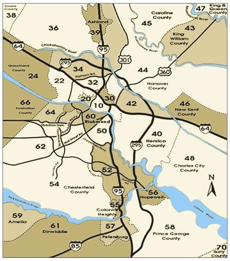
REAL ESTATE ZONES
The greater RVA area is broken up into multiple zones. Below, find a complete list of Real Estate zones in the Richmond Virginia area.
Area 10: City of Richmond
Area 20: West End, Richmond City
Area 22: Far West End, Henrico
Area 24: Goochland County
Area 30: Northside, Richmond City
Area 32: Northside, Henrico County
Area 36: Hanover County
Area 39: Ashland
Area 40: Southeastern Henrico
Area 42: Eastern Henrico County
Area 44: Hanover County
Area 45: King William County
Area 46: New Kent County
Area 48: Charles City County
Area 52: Eastern Chesterfield
Area 54: Chesterfield County
Area 55: Colonial Heights
Area 56: Hopewell
Area 58: Prince George County
Area 59: Amelia & Dinwiddie
Area 60: Southside, Richmond
Area 62: Chesterfield / Midlothian
Area 64: Chesterfield / Midlothian
Area 66: Powhatan County
10-Richmond – Bound by the North by I-64. East, City of Richmond Line.
20-Richmond – Bound on the North by City of Richmond line. East, Powhite Pkwy. South, James River, West, Henrico County line.
22 – Henrico County – Bound on the North by I-64. East, City of Richmond Line. South, James River. West, Henrico County Line
24 – Goochland County – Bound on the north by I-64. East, Goochland County line. South, James River. West, Goochland County line.
30 – Richmond – Bound on the North by City of Richmond line. East, City of Richmond line. South, I-64. West, I-64
32 – Henrico County – Bound on the North by City of Richmond. East, Henrico County line. West I-64.
34 – Henrico County – Bound on the North by Chickahominy River and Henrico County Line. East, Chickahominy River and Henrico County line. South, Parham Rd. and I-64. West, Henrico County line.
36 – Hanover County – Bound on the North by Hanover County line. East, Rt. 301. South, Chickahominy River and Hanover County and C&O RR
40 – Henrico County – Bound on the North by I-64. East, Henrico County line. South, James River. West, James River
42 – Henrico County – Bound on the North by Henrico County line. East, Hanover County line. South, Hanover County line and Chickahominy River. West, Rt. 301.
44 – Hanover County – Bound on the North by Hanover County line. East, Hanover County Line. South, Hanover County line and Chickahominy River. West, Rt. 301
45 – Caroline & King William Counties
50 – Richmond – Bound on the North by James River. East, James River. South, City of Richmond line. West, Rt. 360 (Hull St.)
52 – Chesterfield County – Bound on the North by Chippenham Pkwy. East, James River. South, Chesterfield County line. West, Rt. 10 (Ironbridge Rd.)
54 – Chesterfield County – Bound on the North by Chippenham Pkwy. East, Rt. 10 (Ironbridge Rd.). South, Chesterfield County line. West, Chesterfield County line
60 – Richmond – Bound on the North by James River. South by Rt. 360 (Hull St.) West, Chippenham Pkwy.
62 – Chesterfield County – Bound on the North by Rt. 60 (Midlothian Tpk). East, Chippenham Pkwy. South, Rt. 360 (Hull st.). West, Chesterfield County line.
64 – Chesterfield County- Bound on the North by Chesterfield County line and James River. East, Old Gun Rd, Huguenot Rd, and Chippenham Pkwy. South, Rt. 60 (MidlothianTpk.). West, Chesterfield County